Academia.eduAcademia.edu

Spatial Modeling

description1,434 papers
group20,829 followers
lightbulbAbout this topic
Spatial modeling is a quantitative approach used to represent and analyze spatial phenomena and relationships within geographic data. It employs mathematical and computational techniques to simulate, predict, and visualize spatial patterns, enabling researchers to understand complex interactions in various fields such as geography, urban planning, and environmental science.
"Resumen: Con el presente trabajo pretendemos mostrar una de las distintas aplicaciones que el mundo de los SIG permite; en este caso al mundo medieval de al-Andalus, como ayuda a la hora de comprender y representar gráficamente el tipo... more
Plants stand still and interact with their immediate neighbors. Theory has shown that the distances over which these interactions occur may have important consequences for population and community dynamics. In particular, if intraspecific... more
It is anticipated that climate change will have a major impact on High Arctic ecosystems. Peary caribou (Rangifer tarandus pearyi) is a caribou subspecies endemic to the Canadian High Arctic. In the past four decades, population dynamics... more
The scientific and political interest in Andean rock glaciers has strongly grown in recent years due to the increasing recognition of their hydrological importance and recent impacts of mining on rock glaciers. We present a review of the... more
[EN] This work uses ideas of Foucault, Clastes, and Lévi-Strauss to develop an approach to the conceptualization and symbolic use of space and time which legitimized and made possible the construction of megalithic and earlier Neolothic... more
This study is an intellectual exercise aimed at filling the theoretical and practical lacuna of GIS applications for intra-site analysis. It has long been argued that this lacuna is principally the consequence of the inability of GIS to... more
Traditional approaches to urban and field survey in archaeology and related disciplines (ancient sources, archive data and historical cartography, GIS processing, surface artefacts collection…), are nowadays growingly supported by a wide... more
Sediment delivered from water erosion causes substantial waterway damages and water quality degradation. A number of factors such as drainage area size, basin slope, climate, land use/land cover may affect sediment delivery processes.... more
The aim of the paper is both to review the scientific literature about spatial data mining methods - in particular spatial clustering methods developed in recent years - and to present an original application of the recently proposed... more
I analyze oligopolistic competition among three or more firms located on Hotelling's (1929) Main Srreet and show that in contrast with Hotelling's duopoly, the symmetric locational structure supports a noncooperative equilibrium in... more
I analyze oligopolistic competition among three or more firms located on Hotelling's (1929) Main Sreet and show that in contrast with Hotelling's duopoly, the symmetric locational structure supports a noncooperative equilibrium in prices.... more
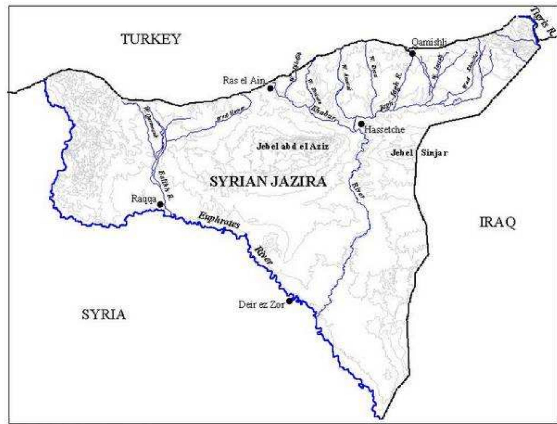
"Most of the datasets presented in this thesis are available for free in ArcGIS shapefile format on the University of Edinburgh's DataShare Open data repository at http://datashare.is.ed.ac.uk/. These datasets are available for everyone... more
Spatial analysis has been a significant field of tourism geography for over 40 years. Yet despite its significant contribution to tourism planning and management and spatial knowledge of tourism and its effects it has been an... more
In this paper, the subspecies category was discussed through European and Anatolian ground squirrel living in Turkey.

Keywords: Anatolian ground squirrel; European ground squirrel; Spermophilus; subspecies category
In one of the 10 driest country in the world, Amman consumes 40 % of the national water. Amman water supply are rare, far away and over exploited. Amman first pump station was built in 1928 for the new quarters of the City. Until 1952,... more
Between 16 and 22°S in the Central Andes the climate is seasonally arid with precipitation decreasing south-westwards. The lowest altitude of rock glacier activity corresponds closely to the 0°C isotherm, not the glacier ELA which rises... more
This paper summarizes an archaeological survey methodology aimed to contrast and to improve the information contained in the Archaeological Inventories about the closest area to “El Casetón de la Era II”, the first enclosure excavated in... more
Soil erosion is a serious environmental and production problem in south Portugal. The objectives of the study were to develop and validate a soil erosion-predicting model based on the revised Universal Soil Loss Equation (RUSLE) in a... more
Aim  To develop a new modelling approach for spatially autocorrelated non-normal data, and apply it to a case study of the role that fire–vegetation–soil feedbacks play in maintaining boundaries between fire-sensitive and fire-promoted... more
The influence of innovative management alternatives (participatory governance, effort management, decision rules) on biological robustness (BR) in various fisheries relevant to the EU (Baltic, Western Shelf, Faroe Islands, North Sea), was... more
In mountain regions, permafrost is important for the geomorphology of high altitudes areas as well for the water resources of inhabited watersheds. Under the present Global Warming, the possible degradation of permafrost during the coming... more
Moutain areas are occasionaly affected by complex mass movements of high magnitude and large extent, which generally involve water, snow, rock and ice in variable proportions. Those events can take the form of rock avalanche, landslide,... more
Dentro de los estudios de análisis del territorio el comportamiento visual de los yacimientos arqueológicos juega un papel fundamental para la comprensión de las estrategias de ocupación del espacio. En el caso que ahora nos ocupa, el... more
The predictive power of logistic regression, support vector machines and bootstrap-aggregated classification trees (bagging, double-bagging) is compared using misclassification error rates on independent test data sets. Based on a... more
The performance improvements that can be achieved by classifier selection and by integrating terrain attributes into land cover classification are investigated in the context of rock glacier detection. While exposed glacier ice can easily... more
El análisis de los incentivos regionales sobre las decisiones de localización empresarial ha sido objeto de gran interés por parte de la economía regional. Sin embargo, son escasos los estudios que han contrastado en términos de... more
Kokap subdistric is located in Kulonprogo. It has some problems of landslides and mis use of land. The research was proposed to determine the regions having potential of land degradation based on the land capability and population... more
In the context of a general retreat of glaciers in the dry Andes, this study focuses on the state and recent evolution of debris-covered glaciers and permafrost-related landforms, especially rock glaciers, in the semiarid to semihumid... more
The Laurichard active rock glacier is the permafrost-related landform with the longest record of monitoring in France, including an annual geodetic survey, repeated geoelectrical campaigns from 1979 onwards and continuous recording of... more
A conference paper /in Czech/ describing two complementary approaches to the spatial investigation of the prehistoric cemetery at Holešov, Moravia, Czech Republic. GIS, multivariate statistics, and a combination of these have been... more
Coral reef ecosystems are topographically complex environments and this structural heterogeneity influences the distribution, abundance and behavior of marine organisms. Airborne hydrographic lidar (Light Detection and Ranging) provides... more
Effective management of coral reef ecosystems requires accurate, quantitative and spatially explicit information on patterns of species richness at spatial scales relevant to the management process.We combined empirical modelling... more
Download research papers for free!